| Title: | Atlas de Chile: mapas (II) |
| Authors: | Türke, Juan |
| Date: | 1895 |
| Publisher: | Eduardo Cadot |
| Type: | Mapa |
| Description: | Mapas de las provincias de Linares (IB25-36), Maule (IB25-35), Ñuble y Concepción (IB25-34), Arauco (IB25-33), Bío-Bío y Malleco (IB25-32), Cautín (IB25-31), Valdivia (IB25-30), Llanquihue (IB25-29), Chiloé (IB25-28) y territorio de Magallanes (IB25-27). Mapas del Atlas de Chile. Santiago: E. Cadot, 1895 |
| Country: | Chile |
| Source: | Iberoamerikanisches Institut, Berlin |
| Appears in Collections: | Relics & Selves: Iconographies of the National in Argentina, Brazil and Chile |
Files in This Item:
| File | Description | Size | Format | |
|---|---|---|---|---|
| IB25-27.tiff | IB25-27 | 3.83 MB | TIFF | 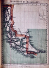 View/Open |
| IB25-28.tiff | IB25-28 | 3.88 MB | TIFF | 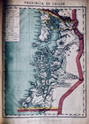 View/Open |
| IB25-29.tiff | IB25-29 | 3.68 MB | TIFF | 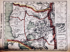 View/Open |
| IB25-30.tiff | IB25-30 | 3.75 MB | TIFF | 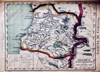 View/Open |
| IB25-31.tiff | IB25-31 | 3.92 MB | TIFF | 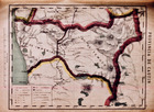 View/Open |
| IB25-32.tiff | IB25-32 | 3.96 MB | TIFF | 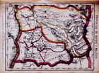 View/Open |
| IB25-33.tiff | IB25-33 | 3.81 MB | TIFF | 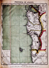 View/Open |
| IB25-34.tiff | IB25-34 | 3.84 MB | TIFF | 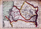 View/Open |
| IB25-35.tiff | IB25-35 | 3.68 MB | TIFF | 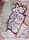 View/Open |
| IB25-36.tiff | IB25-36 | 3.75 MB | TIFF | 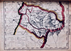 View/Open |
Items in FDA are protected by copyright, with all rights reserved, unless otherwise indicated.