Full metadata record
| DC Field | Value | Language |
|---|---|---|
| dc.contributor.author | Alemann, Theodor | - |
| dc.coverage.spatial | Chile | en |
| dc.date.accessioned | 2019-08-27T00:54:49Z | - |
| dc.date.available | 2019-08-27T00:54:49Z | - |
| dc.date.issued | 1898 | - |
| dc.identifier.uri | http://hdl.handle.net/2451/60340 | - |
| dc.description | Vista general y detalles del mapa de Theodor Alemann en Emilio Lamarca, Boundary Agreements in Force Between the Argentine Republic and Chili, Buenos Aires: 1898 | en |
| dc.source | Iberoamerikanisches Institut, Berlin | en |
| dc.title | Karte der zwischen Argentinien und Chile streitigen Grenzgebiete | en |
| dc.type | Mapa | en |
| Appears in Collections: | Relics & Selves: Iconographies of the National in Argentina, Brazil and Chile | |
Files in This Item:
| File | Description | Size | Format | |
|---|---|---|---|---|
| IB22-15.tiff | IB22-15 | 4.37 MB | TIFF | 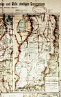 View/Open |
| IB22-16.tiff | IB22-16 | 3.19 MB | TIFF | 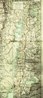 View/Open |
| IB22-17.tiff | IB22-17 | 2.76 MB | TIFF | 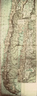 View/Open |
| IB22-18.tiff | IB22-18 | 2.49 MB | TIFF | 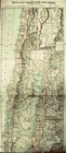 View/Open |
Items in FDA are protected by copyright, with all rights reserved, unless otherwise indicated.