Full metadata record
| DC Field | Value | Language |
|---|---|---|
| dc.contributor.author | Pissis, Aimé | - |
| dc.coverage.spatial | Chile | en |
| dc.date.accessioned | 2019-08-30T01:10:05Z | - |
| dc.date.available | 2019-08-30T01:10:05Z | - |
| dc.date.issued | 1875 | - |
| dc.identifier.uri | http://hdl.handle.net/2451/60358 | - |
| dc.description | Volcán de Peterga (IB24-19), interior del cráter del volcán de Antuco en 1869 (IB24-18), corriente de lava del volcán de Osorno (IB24-17), plano de grupo volcánico (IB24-16), minas de Chanarcillo (IB24-15), ventisquero del Río de los Cipreses (IB24-13) y distribución de vegetales... (IB24-12) en Atlas de la geografía física de la República de Chile. Santiago: Instituto Geográfico de París / Ch. Delagrave, 1875 | en |
| dc.publisher | Instituto Geográfico de París / Ch. Delagrave | en |
| dc.source | Iberoamerikanisches Institut, Berlin | en |
| dc.title | Atlas de la geografía física de la República de Chile (III) | en |
| dc.type | Impreso | en |
| Appears in Collections: | Relics & Selves: Iconographies of the National in Argentina, Brazil and Chile | |
Files in This Item:
| File | Description | Size | Format | |
|---|---|---|---|---|
| IB24-12.tiff | IB24-12 | 3.48 MB | TIFF | 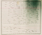 View/Open |
| IB24-13.tiff | IB24-13 | 4.01 MB | TIFF | 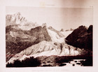 View/Open |
| IB24-15.tiff | IB24-15 | 4 MB | TIFF | 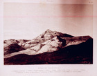 View/Open |
| IB24-16.tiff | IB24-16 | 4.38 MB | TIFF | 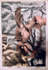 View/Open |
| IB24-17.tiff | IB24-17 | 4.21 MB | TIFF | 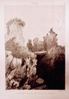 View/Open |
| IB24-18.tiff | IB24-18 | 3.96 MB | TIFF | 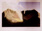 View/Open |
| IB24-19.tiff | IB24-19 | 4.03 MB | TIFF | 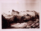 View/Open |
Items in FDA are protected by copyright, with all rights reserved, unless otherwise indicated.